Helmholtz-Alliance “Remote Sensing and Earth System Dynamics”
The HGF Alliance “Remote Sensing and Earth System Dynamics” aims at the development and evaluation of novel bio/geo-physical information products derived from data acquired by a new generation of remote sensing satellites; and their integration in Earth system models for improving understanding and modeling ability of global environmental processes and ecosystem change. The key objective of the Alliance is to prepare the HGF centers and the national/international science community for the utilization and integration of bio/geophysical products provided by the next generation radar remote sensing missions (e.g. Tandem-L) into the study of natural and anthropogenic impact on Earth’s ecosystems. The activities at IBG 3 include multi-scale ground measurements data for the validation of remote sensing products, the optimal combination of active and passive microwave measurements of soil moisture, and the data assimilation of multi-scale soil moisture products.
Data acquisition includes multi-temporal multi-spatial soil moisture measurements, soil and vegetation properties, and hydrometeorological properties. On the basis of this data a multi-scale multi-temporal brightness temperature and soil moisture reference data set is generated. Measurements of an airborne L-band sensor (PLMR2) as well as ground-based mobile measurements performed with the truck mounted JÜLBARA L-band radiometer are used for calibration. The radiative transfer parameters will be estimated using a data assimilation approach, which is particularly relevant for spaceborne radiometers such as SMAP and SMOS.
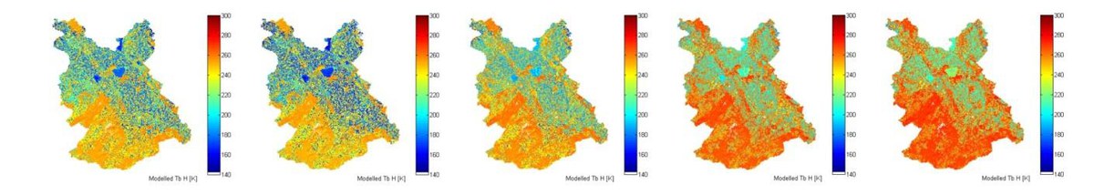
Time series of modeled area-wide horizontal brightness temperatures
Another aim is to optimally combine active and passive microwave measurements of soil moisture by developing new fusion and downscaling algorithms to derive high-resolution near-surface soil moisture fields. For this study we use airborne data from the passive PLMR2 as well as the active DLR F-SAR system. Since 2012 we fly both sensors on a joint platform, the DLR Do-228. These data sets serve as test cases in order to analyze different fusion techniques in support for the SMAP mission, in order to obtain soil-moisture data at an improved spatial resolution. Airborne measurements as well as long term measurements from ground-based sensors are used to identify vegetation dependent downscaling parameters to characterize the effect of vegetation in retrieving surface soil moisture from combined measurements. This approach will be transferred to the operational utilization in the processing of SMAP products.
The goal of the mentioned activities is to utilize the generated data sets in a multi-scale soil moisture sequential data assimilation (SDA) procedure. We set up a land surface model for the Rur catchment, and assimilate the in situ soil moisture measurements and remote sensing products.
Dr. Carsten Montzka
Francois Jonard
Prof. Harrie-Jan Hendricks Franssen
Dr. Heye Bogena
Prof. Harry Vereecken