Assimilating soil moisture network data for characterizing a hillslope
This research project explores the potential of the fully coupled land surface-subsurface model TerrSysMP at the hillslope scale in combination with the sequential data assimilation algorithm Ensemble Kalman Filter (EnKF) at the hillslope scale. Studies applying the EnKF or its derivatives to integrated terrestrial models are mainly limited to synthetic test cases or simplified (subsurface) setups in case of real-world studies. Complex subsurface structures (e.g. 3D heterogeneous fields of subsurface hydraulic properties) and their impacts on the EnKF performance for fully integrated subsurface land-surface models have not yet been investigated. It is expected that the combination of the EnKF and TerrSysMP in a high spatial and temporal resolution at the hillslope scale will increase the insight into the EnKF performance for integrated terrestrial models.
The particular focus of the project is on the assimilation of soil moisture information from a sensor network with TerrSysMP-PDAF and its impact on discharge and evapotranspiration as well as the spatial patterns of soil moisture. In our experiments we hence address the following research questions:
- Can soil moisture, evapotranspiration and discharge at the hillslope scale be better characterized with the continuous assimilation of observations from a dense network of soil moisture sensors?
- How does updating soil hydraulic parameters, besides states affect the EnKF performance?
- Is the joint update of saturated hydraulic conductivity and model states sufficient to constrain the estimates with the fully coupled land surface-subsurface model with spatially heterogeneous soil hydraulic properties or is an adjustment of additional soil hydraulic properties (e.g. inverse air entry) required?
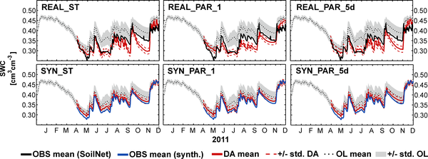
- What is the difference between assimilating real-world data and synthetic data mimicking the study site? Systematic differences in the performance of DA between synthetic experiments and real-world experiments potentially point to structural model errors i.e. processes not included by the model.
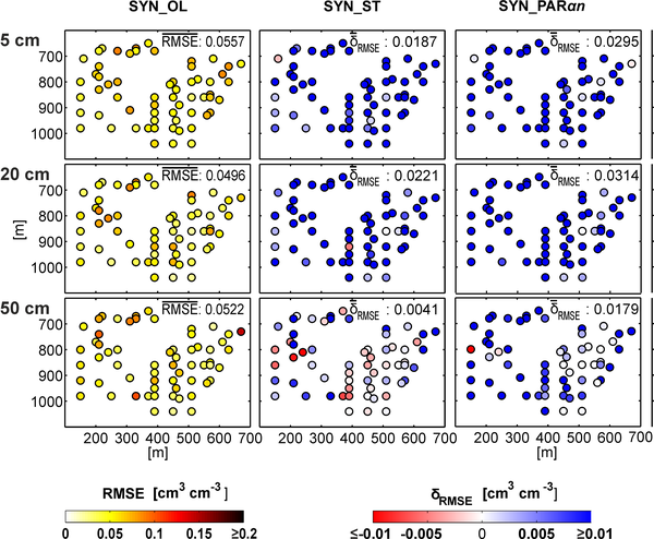
On this account, ParFlow-CLM is applied to the 38 ha Rollesbroich head-water catchment in the Eifel (Germany) within TerrSysMP-PDAF. The model ensemble currently consists of 128 different model realizations with a lateral resolution of 10 × 10 m (0.3 million unknowns), stochastic forcing (precipitation) and fully heterogeneous stochastic van Genuchten soil hydraulic properties. Soil moisture observations are assimilated from May to December 2011. The verification period is the year 2012.
This study was carried out for the grassland catchment Rollesbroich. The study site is part of the Terrestrial Environmental Observatories (TERENO) infrastructure initiative and provides detailed long term high resolution data on soil water content, discharge and actual evapotranspiration for model parametrization and validation. Soil water content is measured with a wireless sensor network (SoilNet) at 182 points distributed over the entire study site. Soil water content and soil temperature at 5, 20 and 50 cm depth are derived by capacitance probes using an empirical relationship between soil water content and permittivity. Actual evapotranspiration are measured by six lysimeters (SoilCAN) and a nearby eddy covariance station. The observations further include discharge measurements by Venturi and Thompson gauges as well as tipping bucket precipitation measurements.
Results indicate that the joint update of model states and hydraulic conductivity was more efficient than updating soil water content alone. However, the improvement of the soil water content characterization in the verification period was small and the estimated hydraulic conductivity was not sufficient to reduce the open loop model bias of the real-world experiments, although in the assimilation period improvement was observed. Synthetic experiments gave more favorable results than real-world experiments suggesting that the real-world experiments are most probably affected by structural errors. Moreover, soil water content assimilation only marginally improved the estimation of discharge and evapotranspiration. A reason could be that discharge is potentially more sensitive to other model parameters (e.g. Manning’s roughness coefficient). On the other hand, evapotranspiration was mostly energy-limited during the simulation period and hardly water-limited. Under energy-limited conditions, actual evapotranspiration is not very sensitive to soil moisture content.
Relevant publications:
Gebler, S., H.J. Hendricks Franssen, S.J. Kollet, W. Qu and H. Vereecken, 2017. High resolution modelling of soil moisture patterns with TerrSysMP. A comparison with sensor network data. Journal of Hydrology, 547, 309-331.